The dogs have been taught not to tear up anything so they didn't want to open their gifts but the cats didn't hesitate when offered the chance of opening gifts and playing in gift wrap paper.
Your life is not about what people expect you to be. It's about following your heart to be what you want to be.
Saturday, November 30, 2013
Mendenhall Glacier
Thursday, August 26th - - Mendenhall Glacier, a short drive from downtown Juneau, was first named Auke Glacier in 1879 by John Muir. In 1892 it was renamed to honor Thomas Corwin Mendenhall (1841-1924) who served as Superintendent of the U.S. Coast and Geodetic Survey from 1889 to 1894.
The Mendenhall glacier flows for 12 miles down the Mendenhall Valley to its terminus near the visitor center. The ice flows forward at an average rate of 2 feet per day, but at the very same time, it wastes away at a slightly faster rate. Waste occurs through melting or when large pieces of ice break off the face of the glacier. When the rate of melting exceeds the rate of flow, a glacier recedes. The Mendenhall glacier has been receding since the late 1700's and currently retreats at a rate of 25-30 feet per year.
Mendenhall Glacier as seen from the rear of my campsite at Mendenhall Lake campground in the Tongass National Forest. The full face of the glacier cannot be seen from this vantage point because it is blocked by the bit of land jutting out from the left.
The view from the Visitors Center. We are seeing only a very small portion of the glacier as it extends 12 miles back down the valley.
A little bit closer.
An awesome waterfall flows down from above. Another waterfall can be seen in the far distance to the right of the glacier.
A ride on the lake gets you a little closer to the face of the glacier.
Some of the larger icebergs floating in Mendenhall Lake. Icebergs are created when the glacier calves (chunks of ice fall off the face of the glacier).
I couldn't resist picking up a chunk of glacial ice that was floating close to the shore. It was crystal clear and many, many years old. And it was cold...
Friday, November 22, 2013
Red Vase
I think that this red vase may be depression glass or carnival glass. Other than that I know nothing about it.
Monday, November 18, 2013
Lyddington - Seaton - Bisbrooke - Uppnham - Lyddington
With Harry and Jenny. Beautiful weather, very hot, good underfoot. Pretty fast pace, considering. Including looking round Uppingham - 8.7 miles.
It's a delight to show our countryside to someone who hasn't seen it before!
sculpture inspired by the fishponds |
Lyddington church from the ancient fishponds |
The first part of the path is clearly marked as the Rutland Round. We walk across the Green, past the sculpture, through a gate and with the hedge on our left walk through the fields with the traces of the old fishponds. At the end of this field we turn left, skirting a wood, before turning right and heading along a path uphill. This was shaded and cool before we cam out into the fields. We head north east for a little while, then do a dog-leg. This is all clear on the ground with waymarker posts. The path gradually turns further east, alongside a sloping ploughed field.
We come out into Grange Lane, which leads uphill into Seaton.
A solitary wood pigeon |
swallows are gathering |
We walk through Seaton and take a look at the viaduct from the Glaston Harringworth cross roads, before going back to our path.
Seaton church |
The path is not far from Moles Lane, and up a short set of steps. It heads north, and climbs gently before descending more steeply to the dismantled railway. Here it turns north west, and crosses a large field with a stream - again the waymarkers are clear. The path now runs beside trees and is enclosed on each side - it climbs almost unnoticeably into Bisbrooke, emerging behind the church.
We follow the road to the cross roads, meeting the odd chicken, and helping ourselves to some windfalls, offered free outside one of the houses.
At the crossroads we go straight ahead then turn left and right at the corner - the road becomes a track and then a path, and finally we arrive at the Uppingham School playing field and cricket pavilion. Into the town for coffee and lunch at Don Paddys, before looking round the town, and the Goldmark Gallery - there's an exhibition of George Grosz's work, and lots of other interesting items.
We leave Uppingham by taking the path through the church porch and churchyard, then at the road we turn left then right and head south and downhill. There are some juicy blackberries on the way, so we pick them - making use of empty water bottles. Tonight we shall feast.
The path is clear, leading us to the playing field behind Uppingham College. We lose the track briefly, but find it again and it leads south east across a road, and over farmland towards Lyddington.
That's what I call a path "made good" |
A short diversion as we feed an apple to a horse, we reach the road into Lyddington and decide to walk through the village back to the car.
This bird is going nowhere! |
Power: Nature turned Generator
The rain seems to have stopped and now you can hear the Longmire generators (6-10 am and 4-8 pm that is). It's going to take some time to put things back in order, but it seems as though the main brunt of the storm and its damage have subsided.
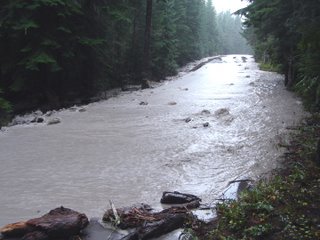
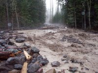
Sunshine Point Campground near the Nisqually Entrance was disappointed with the weather trend and left Mt. Rainier National Park for sunnier locations. The problem is that it took the main road with it. I couldn't get a visual though because the road near Kautz Creek was under 3 feet of silty debris and water. The creek must have diverted upstream and chosen a new channel. See photo above.
If you're familiar with the park, you'll notice a number of "new viewing areas" along the Nisqually to Paradise corridor next time you visit. The Nisqually River ran bank to bank and in doing so, took a massive amount of debris with it. Large trees fell, as new embankments were chiseled.
Here is another image of the westside road. See it? Neither do I. Well, 8 pm is approaching...
Monday, November 11, 2013
Happy Holidays from Shore Acres!
Today I had planned on being in California, but last night I had heard about this incredible Christmas light display at Shore Acres State Park. I wanted to visit Shore Acres anyway, since I knew that it could be an incredible place for viewing waves breaking against the cliffs. But that alone wasn't enough to make me want to put off going to California for one more day. However, once I heard about the Christmas light display, I knew I had to check it out.
I arrived at the park in the early afternoon so I could watch the waves for a while. I've heard stories of days where you get drenched from the spray coming off the waves, and while there were some pretty impressive waves, they weren't big enough to send spray over the top of the cliff where the viewing area was located. Nonetheless, it was awesome to witness the power of the ocean in such a beautiful place.
After the sun went down, people started showing up for the light display. According to the "Friends of Shore Acres" website, the light display is made possible by support from local businesses and the hard work of more than 1,500 volunteers. The holiday display uses "about" 275,000 lights, the majority of which are L.E.D. lights. The display draws around 40,000 to 50,000 visitors each year.
I shot a few video clips of the light displays, too. If you'd like to view them, click on this link which will bring you to the video gallery on my main photography website:
http://www.travisnovitsky.com/Video-Clips/Misc-Videos/4207197_KrddQ
Route updates and more incidents
There are a number of climbing conditions updates now that the mountaineering rangers are regularly patrolling the standard routes. The Gibraltar Ledges, Emmons, DC, and Kautz were all climbed last week and we still welcome your reports if you're out and about...
This weekend went by without a mountaineering "accident," but their were "incidents." The first one involved three climbers who separated while descending from high camp on the Kautz Glacier. Two climbers (the faster pair) took off hoping to wait (relax) in the parking lot for their buddy. Can you guess what happened next? After spending much of the day wondering where their "teammate" was, the climbers finally contacted the NPS hoping to initiate a search. Sparing you the details, the third climber eventually showed up on his own many hours later. During which, his buddies were sent out to retrace their descent. Free advice: if you set out as a team, stick together. This is especially the case on descents that involve glacier crossings and cloudy/whiteout type weather.
And once again, we had another team use a cell phone to call their emergency contact and 911 for information and directions. Thankfully, the climbers worked out the issue before the NPS had to dispatch a climbing ranger team. Really, be prepared to sit out bad weather (which is common) on Mount Rainier, or become fodder for this blog. ;)
And speaking of cell phones, I've been getting a few questions about the "preferred" cell phone provider on the mountain. Truth is, I don't know. I think that each service does better in some places and elevations than others. That said, I'd be curious to get your comments on where your cell phone has worked and where it didn't (we know they work well on Liberty Ridge BTW). If you've used one while climbing (it can be fun to call a friend while on the mountain) send me your comments so that they can be shared with other climbers.
The last and most significant mountain "related" news involves a search for a missing day-hiker on Eagle Peak. A 47 year old man didn't return from his hike last Saturday. I suspect that there will be more information released on this issue if things don't get resolved soon, stay tuned.
And if you're wondering, the opening photo is from the now famous Camp Schurman toilet seat. Dmitry Shapovalov's wanted to share the view with all of you. But if you head up there today, don't expect to see this unless you leave the NEW door open! Let's hope that this one makes it through the summer.
Sunday, November 10, 2013
Kings Canyon :: Bubbs Creek Trail
The Bubbs Creek Trail follows the South Fork Kings River to Avalanche Creek and on to Bubbs Creek. A little over two miles long, it is the first leg of the hike to Mist Falls (2.5 miles further), which was my ultimate destination. The trail starts out on the north side of the river. Crossing a suspension bridge gets you to the south side where the trail meanders through meadows dotted with ponderosa pine and cedar trees. Towering peaks rise up on both sides of the river dwarfing everything beneath them.
A calm section of the South Fork Kings River. The big boulder in the distance is known as the Muir Rock. From this wide, flat rock, John Muir used to deliver impassioned speeches about the Sierra. When referring to logging the giant trees, he said that mankind may as well "sell the rain clouds and the snow and the rivers to be cut up and carried away, if that were possible."
Narrow spots in the river, along with boulders and rocks in the water, create sections of rough water. I love the sound of the water flowing through these areas.
There were some areas along the trail that required scrambling over rocks, but for the most part the trail was relatively level with open meadows mingled with forested areas. About three quarters of the way down the trail there were several small streams that had to be crossed using rocks as stepping stones, or simply walking through the shallow, swift flowing waters.
But then I came to this. The three logs were 8-10 feet long. The water was about 18” deep and very, very fast. I stuck my hiking stick in to the bottom of the stream and the current almost grabbed it out of my hand. It's hard to see in the photo but once you got across the wet, slippery logs there was a downed tree that you had to get over and another 10 feet or so of water (though it didn't look quite as deep) before you reached the other side.
Three times I made the attempt to cross. The logs were of varying sizes. They were slippery. There was no good footing and I'm not good at walking the balance beam! I looked upstream and down for another way to cross but saw nothing. There was no one else around to offer assistance. Reluctantly, I turned around and walked back the way I had come, disappointed but at the same time, savoring the beauty around me.
Along the way back I thought of my options. I could go to the beginning again and take the trail on the North side of the river but that would make the days hike 12.5 miles instead of the original 8.5 and though the view at Mist Falls promised to be nice (a 50 foot waterfall that drops over a ledge into a boulder-lined pool) I decided not to continue on to the falls.
Saturday, November 9, 2013
Gear for Sale
I'll be adding more gear, clothing and boots and deletingthe itemsthat havesold on a daily basisfor the next week or so. Happy to ship Internationally if you are willing to pay the postage.
More here if interested:
http://coldthistletools.blogspot.com//12/cold-thistle-review-gear-for-sell.html
Smoothies All Around!
No sooner had I returned from New York over the weekend, than the Soma Smothie I'd been anticipating for review had arrived. So I took a break from the loop frame delirium of the New Amsterdam Bicycle Show and immediately took it for a spin. Soma roadbikes are not very common here on the East Coast. So imagine my surprise when on my way home I encountered another Smoothie!
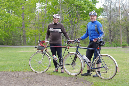
As I stopped to snap some pictures at the end of my ride, these gentlemen recognised me and we had a nice chat about their 650B conversions - one a vintage Andre Bertin and the other a Soma Smoothie ES with a Bontrager fork. I am so happy to be back home! Where else but in Boston does one encounter this sort of thing?
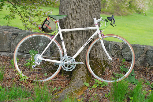
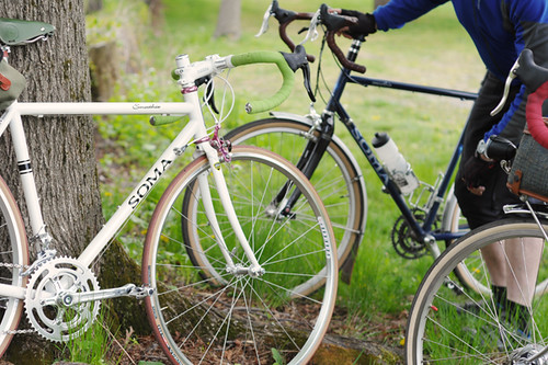
But enough about other people's bikes for now, and here is more about the one I am riding. This Soma Smoothie is on loan for review directly from the manufacturer. It is a 52cm steel frameset that was built up to accommodate my Campagnolo lever preferences, which was very nice of them. Everything shown on the bike is directly from Soma, except for my bag and pedals.
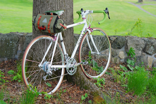
I have not weighed the bike yet, but (without saddlebag) it feels pretty similar to my vintage Moser - so I'd say around 21lb.Described as a road/race frame, the Smoothie nonetheless has eyelets for fenders and clearances for 28mm tires.
One thing it does't have? Toe overlap! That's right: Here is a stock 52cm road/racing bike with no TCO. They exist. I wear size 37-38 shoes and with 23mm tires there is a boatload of clearance (well maybe it's a small boat, but still). I can definitely fit it with 25mms without a problem, maybe even 28mm.
The pearly white colourscheme is adaptable to a wide range of aesthetics, from classic to colourful to stark. The TIG welded frame will not satisfy lug lovers but is solid and smooth-jointed. It is a versatile, unobtrusive frameset. A carbon fork is available in place of the standard steel one for those wishing to go that route.
This is not a review, so I won't go over the details of the build at this stage. But as far as first impressions (and mind you this is after just 25 miles), a couple of things stand out: First, it is smooth - as advertised. And I am talking about ride quality: very comfy over bumps and I do not feel any road vibration. And second, it handles tamely and predictably. No twitchiness and very precise cornering at the moderate speeds maintained during my conservative "shake down" ride.
The Smothie ES owner I met on the road is very happy with his bicycle, which he's got outfitted with 32mm tires and fenders. I will refrain from writing more about the bike I have on loan until I ride it extensively, but at under $400 for the frame, I am impressed so far. We need more of these on the East Coast and I hope some local shops will carry floor models in the near future.
Subscribe to:
Posts (Atom)