Your life is not about what people expect you to be. It's about following your heart to be what you want to be.
Friday, September 30, 2011
Enchantments Traverse
At about 2 hours into the hike, we arrived at Colchuck Lake.
A couple of hours later, we made it to the upper basin and started seeing mountain goats.
Then we ran into a few well-camouflaged Rock Ptarmigans.
We couldn't resist standing on the collapsed snow cave.
Ron and Doug ontop of 8,440' Little Annapurna. Mt. Stuart and Dragontail Peak in the background.
Prusik Peak, Mount Temple and several of the alpine lakes.
Little Annapurna as seen from Perfection Lake.
Some people say that this is the most beautiful place in Washington State. We've been to some amazing places. I can think of several that are close, but none better!
Monday, September 26, 2011
Maple at Hemme
A bigleaf maple tree in the Las Trampas Regional Wilderness at Hemme Avenue in Alamo. This photo was taken back in April.
Right now, this area is dry and dusty, eagerly awaiting the first drops of winter rain...
Wednesday, September 21, 2011
Glacier Peak
The trail goes through about 7 miles of forest and then climbs up to join the Pacific Crest Trail. The hillsides are covered in Heather and numerous wildflowers. We must have crossed 20 small streams on the way.
After almost 10 miles of hiking, we get our first look at the mountain. At this point we are still several hours from our high camp.
The clouds started to roll in during the night. We had to get going earlier than we had planned to try to summit while we had a chance. Our route took us over parts of the Gerdine and Cool Glaciers. This large crevasse was near Disappointment Peak.
Climbers nearing the top.
Emily, Doug and Dave on the summit. The Glacier Peak Wilderness is full of inviting snow covered peaks.
We broke camp and started the long hike back to the car. As we headed out, clouds began to cover the mountain. Pretty soon we could hear distant thunder.
We saw a few marmots along the way.
Tiger Lilies beside the trail.
We made it back to the car before dark. The downpour began soon after that.
With the low elevation trailhead, the long approach and a lot of ups and downs, this climb was as taxing as climbing Mt. Rainier. It was nice to finally stand on top of the mountain that we have seen so many times from other summits.
Tuesday, September 13, 2011
Barnwell Country Park - Ashton - Polebrook - Barnwell
A few examples of the fauna spotted en route
homo sapiens sapiens |
ardea cineria |
Carterocephalus palaemon - chequered skipper |
Felis catus culmis - the thatched cat |
Apart from these we saw Canada geese, a goldfinch, house martins, horses and donkeys, one sheltering from the rain. Then lots of cows, calves and bullocks, swans and cygnets, and a couple of piglets, who seemed quite excited to spot us from across the road. By this time my camera was tucked away in my rucksack, and I was too wet to take photos. Worth keeping a change of clothes handy for wet weather wanders.
Ashton church |
We started this walk from Barnwell Country Park, making our way to the Mill (Oundle or Barnwell?) with its guillotine lock gate. Just opposite this the Nene Way goes North East past Oundle marina, along to another lock where we crossed to the left bank of the river. We walked across the flat field to a gate where we turned very sharply right to return to the river.
We followed the water , going through some trees under the A605. The path and river meanders, and the land is quite flat on the left, but rises more steeply on the right. We could see New Lodge Farm, which we would pass later in the walk.
Along the river there are a couple of weirs and another lock. At one point we watched a heron standing on a long wooden platform, not bothered by our approach.
Still following the Nene Way we turned right to cross the river via a footbridge and the path led us into Ashton, an estate village built by the Rothschilds. The pub,the Chequered Skipper, was renamed from the Three Horseshoes in 1966 by Miriam Rothschild, the celebrated zoologist who lived in Ashton Wold.
After the pub we followed the road as far as a small wood, where an unpaved byway ( a boreen in Ireland) turns right towards Polebrook, leaving the route of the Nene Way. When we reached the road from Polebrook to Ashton we crossed it, walking as far as New Lodge and Red Lodge farms. There is a stile at the gate just before Red Lodge, which leads through fields, past a stable and after another couple of stiles (beware - they can be slippery in wet weather) the path led us into Polebrook, into a lane from where we could see the pub and the church. As it was already raining cats (on a warm thatched roof) we didn't hang about to explore, but made our way down the lane, which turned into a track, then an overgrown path before emerging near an industrial building.
We should have turned slightly to the right here on another byway, and ignored the surfaced road off to the left. Eventually on track we walked until we saw a footpath sign pointing up across a recently harvested, and unusually (for this year) muddy field, so we attacked the path, and followed it through yet another field of cows. It rejoined the byway at the farm (Armston Hall). A little way along the road, and another footpath sign showed the way to the left across fields, and past a couple of donkeys, one of them sensibly sheltering from the downpour.
The path touches the edge of Armston Grove woodland - giving us enough shelter for a well-earned snack stop, but not stopping me from making yet another small detour - that'll teach me not to believe footpath signs! Within a hundred yards or so the mistake was clear - no way out of the field. Back we trotted, and from now on we followed the path into Barnwell.We passed behind Barnwell Manor on a grassy path and came into the village just before the Montagu Arms. Here we turned right along the road,then right again to rejoin the Nene Way as it follows Barnwell Brook past the manor again and the remains of the castle. We were too wet to bother looking around in any detail. At a T-junction we turned right along the road and carried on until we saw a sign to the left for the Nene Way. This took us to the Oundle bypass (A605) and across to the old road which we followed back to the country park.
- once again one or two unintended detours, but they bumped the mileage up to almost 10!
Saturday, September 10, 2011
Death Valley :: Zabriskie Point
Having been stationed in California, I have visited Death Valley several times the latest being in April ... Like many of our National Parks, each time you visit you see things in a different way. The quality of the light is always different depending upon the time of day and other atmospheric conditions. And the light is what makes things seem to appear different. Because there was so much sand and dust in the air I concentrated this time on the closer views at Zabriske Point, abstracting Mother Nature a bit. There is no sense of dimension in the photos, no way to tell how large or how small the mounds of dirt and rocks really are...
Friday, September 9, 2011
Dynamite M6 First Ascent
Putting work into Dynamite M6 |
Recently I wrote about a mixed climb that I had top roped last season. It was a fun line that I thought was worth investing some time and effort into. In recent days I spent some time equipping the route and giving it a few tries with State College climber and friend Joel Torretti. Early season and tired arms shut me down several times. With a night of rest I managed to get it. This new climb at Irishtown crag in Dunbar is now officially named Dynamite and is roughly M6. Yesterday my faithful partner Laura accompanied me to video, belay and motivate me for the send. With several days pump and some sheer determination I sent. I decided to put a short clip together to show everyone the climb. I hope this motivates more folks to come join in the great winter climbing that Southwestern PA has to offer. This is my first ever attempt at doing any video work, so any feedback is appreciated. click here and enjoy the clip!
My newly created helmet art |
Tomorrowshould be an incredible day. Its Laura and myfirst day back at the local big ice playground. Laura and I are so excited to get our first pure ice day in (maybe). Rumor has it thatice climbing hardmanand old buddy Chip Kamin will be joining us for some tool swinging at some of the biggest local ice he's ever climbed. Dr. Bob, Regina, Felipe, Laura and myself are planning for some big fun on the best looking early season ice in 10 years.Of note, last yearI witnessedan incredible mixed lineform that I hadn't seen in otheryears. If its in tomorrow, I think I may have to investigate. Stay tuned for the details!
Projected corner line (last season) - Ohhhh, Ahhhhhhhh! |
Liberty Ridge - Spring Ascent
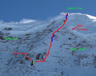
The wintry conditions took more out of the team than expected. In particular, areas of really deep snow became troubling and time consuming. They had intended to spend three nights on route, but needed FIVE and were forced to bivy near 13,000 feet.
In this close up image of the upper route, green dots represent the high camps and bivies and the blue sections represent areas of difficulty or belays. It's interesting to note that the team took the far right variation out of Thumb Rock.
Neal made it clear that "some deep snow" was not going to thwart their summit efforts. A mix of Midwest pride and fortitude pushed the men through the exhausting conditions. And yes, they did wonder about avalanches...
They started late the 1st day and spent the night along the trail in the snow. The 2nd night found them near the access to the Carbon, 7,200 feet. It was up to Thumb Rock for the 3rd and 4th night. Isaac stated that the extra night was needed because,
"As soon as we started to set up camp, my body started to let me know exactly what I had done to it... I threw up before I got in the tent, and... three more times before I could get some Power Gels and water to stay down. I didn't have a headache and I was not concerned it was AMS. The weather was not perfect and when we woke up at 0500. I said I could use another day to recover. They all agreed a rest day was in order so we stayed in the tent all day long."After a recovery, the team climbed a major porition of the upper route. The 5th night was pitched at a bivy site above 13,000 feet. At that camp, Issac described setting anchors into the rock for fear of either being blown or avalanched off the mountain. Thankfully, neither happened.
They belayed two pitches of alpine ice (one was described as 15 fee of WI 4) to reach Liberty Cap. After finding a few crevasses the hard way between Liberty Cap and the summit, the team cautiously descended to Camp Schurman. They spent a final night in the hut, but only after digging it out. Somehow, the door had blown open during the winter and for the most part, the hut was filed with snow...
The team intends to post a trip report on summitpost and cascadeclimbers. You can also find information on Neal Mueller's website.
Successfully climbing Liberty Ridge is quite an achievement this time of year, congratulations and thanks for your help digging out the Camp Schurman hut! Also, thanks to Pandora for sharing her image here.
Thursday, September 8, 2011
Alenax: the Ultimate Vintage Freak Bike?
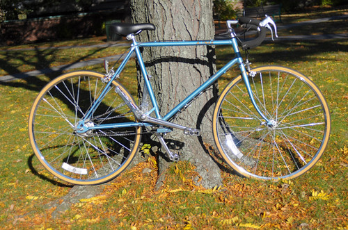
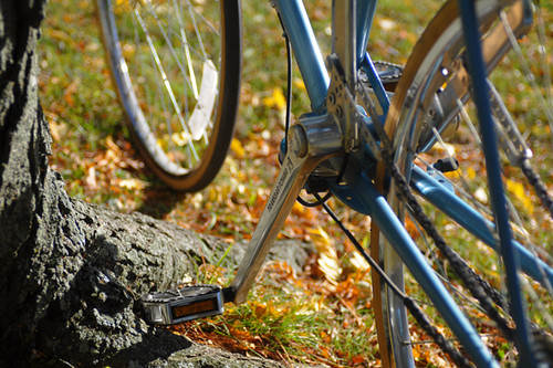
Looking for the perfect bike for that End of the World themed ride? I think I found it. Having seen so many crazy two-wheeled contraptions in the basements and garages of collectors over the years, I sometimes think that I've seen it all and that no bike can really surprise me anymore. And that's usually when I'll stumble upon something like this. Notice anything out of the ordinary?
How about now?
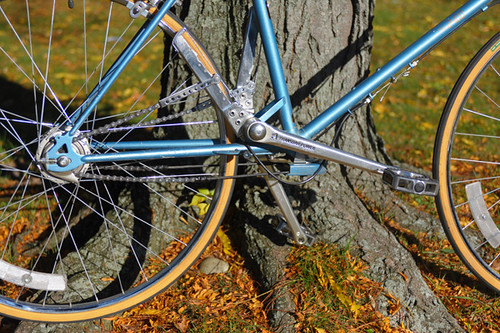
Meet theAlenax TRB 2400, the original Transbar Power bicycle. It was designed to be pedaled using up-and-down motions instead of circular motions. Presumably this was done to approximate the feel of walking, thereby making cycling feel more "natural." Here is a video of this in action.
In leu of a crankset, the Alenax sports two pivoted "transbars." I won't pretend to understand how exactly the system works, but seethis articleby Jobst Brandt andthe Alenax blogfor additional descriptions.
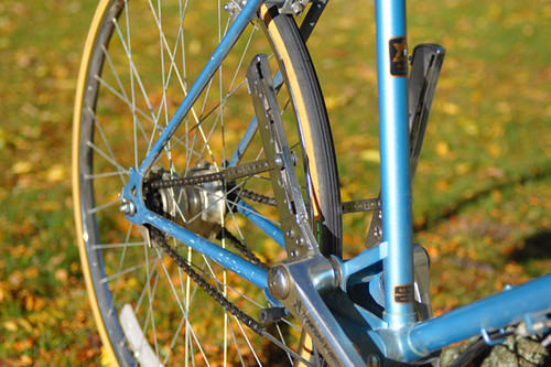
A stem-mounted shifter controls the gears
- on Alenax's own internally geared hub.
Abundance of cables and chains along the drivetrain.
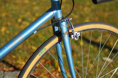
But aside from the pedaling system, the Alenax looks disconcertingly normal. Lugs, skinny tubes, shimmery paint, tan wall tires. It's basically just a typical '80s roadbike, retrofitted to accommodate the Transbar Power system. It is also a good 5lb heavier that a standard roadbike from that era.
When Alenax came out with these bikes in 1983, they marketed aggressively, intending to revolutionise bicycle design. They attended all the bike shows, made promotional videos, courted distributors. But amazingly, the concept failed to catch on. By 1993 they threw in the towel, and all that's left today are the (apparently highly collectible) traces of their efforts. At some point more recently, it looks like there was an attempt to modernise and rebrand, but that too does not seem to have worked out.
I am doing some freelance work for Harris Cyclery, and one of the perks is getting to see things like this. Jon Harris dragged the Alenax out of the shop's basement one day, then proceeded to ride it jauntily up and down the block. "It feels a little strange until you get it up to speed," he explained, "but after that it's fine!" The bike is too big for me to ride, so I cannot confirm that. But they do have a partially assembled step-through version in the basement...
It's Looking Better...
An affidavit by Daniel Bray in the Revolutionary War pension file of his father John Bray, stated that “Some time in the early part of the year 1816, he went to the land office of Cincinnati to enter the North East quarter of Section No 25, town No 2, range 3 West. That owing to some mistake in the land office he could not effect an entry and he was obliged to return home and that his father John Bray, then went to the office and entered the said quarter...”
So the “problem” was: When was the land actually purchased and why did Daniel state that it was in Range 3?
The book “Indiana Land Entries Volume I” by Margaret R. Waters, published in 1948, contains the records for Indiana that are from the Cincinnati Land Office. It covers the area known as the “wedge” in the southeast corner of the state.
The map above shows the status of the Indiana Territory in 1810 with the four counties in existence at the time: of Knox (Kn), Harrison (Har), Clark (Clk), and Dearborn (Dea). The “wedge” mentioned in the Waters book was the area known as Dearborn county in 1810 as well as neighboring portions of Clark County.
By 1814 there were a few more counties in the Indiana Territory. Franklin and Wayne counties were created in 1811 while Switzerland was created in 1814 from that Dearborn “wedge” area as well as from portions of other counties. The two maps above are from the Genealogy Inc. website.
In the introduction of her book, Margaret R. Waters states that the records were copied solely for genealogical purposes to enable a searcher to learn if an ancestor located in Indiana and if so, where and when. To save time and space the acreage and final certificate numbers were omitted. A minimum amount of information is given (name, property description, date of entry) but enough to determine if the person of interest entered land in what would become the state of Indiana.
At the top of page 79 was the entry for John Bray showing that he entered the “NE 1/4 of S25 on 3-5-1816”. The line just below John, includes the name of Edward Ray who may be the same person who married Jane Bray, daughter of John. The previous page (78) showed that the land was in Switzerland County in T2N, R4W of the 1st PM (Township 2 North, Range 4 West of the 1st Principal Meridian).
The map above (from the Waters book) shows the “wedge” area of land from the Cincinnati Land Office included in the book “Indiana Land Entries Volume I”.
This enlarged portion of the previous map shows the townships that comprise Switzerland County. The dotted lines show the boundaries of Switzerland and Ohio Counties. (Ohio County was created in 1844 from Dearborn.) The land that John Bray purchased was in T2N R4W, which is in that tiny red triangle bordering Range 3 West.
Portion of a Switzerland County Map from the My Indiana Home website showing the location of Braytown in Craig Township.
Luckily for me, the Allen County Public Library has a series of microfilms called “Ohio Land Records” which includes the records of the Cincinnati Land Office. Film OLR-110 contained “Cincinnati Land Office Entries, 1814-1829” and it was even indexed by page number. Most of the page numbers were missing or illegible but it didn't take long to find his entry since I had the date he entered the land.
Cropped portion of the page showing the entry for John Bray (last entry on the image). The date at the top shows the transaction was made on March 5th 1816. The text in the column on the right states “John Bray of Franklin County applied to enter the North East quarter of Section 25 Town 2 Range 4 West - Containing 159 44/100 acres and produces the Receiver's Receipt No 30668 dated this day for $79 72/100 amt [?] being the one fourth part of the purchase money of said quarter Section of Land.”
So it seems that the date of March 5, 1816 as given by Carrie Bray in her 1949 article correlates to the date of purchase of the land. It also confirms the statement made by Daniel Bray in his affidavit that he went to the land office in Cincinnati “some time in the early part of the year 1816”.
But there was a surprise in the land entry document - the statement that John Bray was “of Franklin County”.
In searching the web for information, I came across the site Cincinnati Land Office Records, which appears to be a part of the Ohio Memory project even though those records are not included in their list of collections. The site contains images of the original land patents issued to the purchasers. There are only a little over 300 documents currently online but it is going to be an awesome site when they get more documents published. Anyway, at the bottom of the second paragraph of “About this collection” it states
“In certain instances it has been impossible to determine the correct state of origin of the purchaser; generally this is due to the fact that both Indiana and Ohio have identically-named counties, such as Franklin County. In these cases, both Ohio and Indiana have been listed as the state of origin.”
So that might present a little problem. However, Franklin County, Indiana is so very close to Switzerland County while Franklin County, Ohio is further north and east, closer to the central part of Ohio. Since we don't know the whereabouts of John Bray between 1805 and 1816 (as mentioned in The Evidence at Hand) it is possible that he could have ventured further north, but I don't think so. Perhaps that is just wishful thinking on my part. If he was “of Franklin County, Indiana Territory” then that would be evidence that he was actually residing in the area and would definitely be eligible for membership in the Territorial Guard Society of Indiana.
We have the record of the land entry on March 5, 1816 and the statement by Daniel Bray that he, then his father John, went to the Cincinnati Land Office in the early part of 1816. Does that constitute enough evidence to be able to say that they were then residing in the Indiana Territory?
What other records exist during that time period that can be used to help substantiate the claim that John Bray resided in the Indiana Territory in 1816?
All Legs
Well, I finally watched the Triplets of Belleville. For those who have not seen it, this is a French animated film about cycling, music hall singers and sinister men in black - surreal and somewhat disturbing (in a good way). No subtitles required even if you do not understand French.
There are many fascinating details in this film, but I don't want to spoil it for those who haven't watched it. Instead I just want to note one hilarious element: the caricatured cyclist's body.
Ah, the gaunt, emaciated cyclist. Sunken eyes, protruding cheekbones. Head bobbing up and down as if the straining tendons of the neck can barely support it. Hunched back and shoulders. Spaghetti arms. Non-existent waist, narrow hips...And then, suddenly - bang! An explosion of thigh muscle, bulge upon bulge, tapering at the knees before exploding again into freakishly well defined calves. I have seen such exaggerated renderings before, but none as expressively done as in this film. The half-soulful, half-dead look on Champion's face completes the archetype.
I have now met a few real-life cyclists with similar body types. They disguise it surprisingly well when wearing regular clothing, but once in lycra the leg explosion is revealed.Seeing such marvelously distorted proportions in person,I try not to stare. But it's kind of awesome, and awe-inspiring. Gives "all legs" a new meaning.
PS: You can tell it's winter, because I'm falling prey tocycling movies. Any recommendations besides the usual suspects? For now, I'll just have to live with "Belleville Rendez-Vous" stuck in my head...
Tuesday, September 6, 2011
Loon Mother and Baby + Baby's First Swim
We spent the entire day today photographing Loons and had some incredible luck doing so! When we came upon this nest, there was one chick already born and snuggling under mom's wing. After our mid-day lunch break we returned to find that the second chick had hatched while we were away! It was an incredible day :-)
Just moments after leaving the nest, a baby Loon gets its first taste of life on the water. If you look just above the beak of the Loon on the left, you can see the nest and the egg shells in the background.