Your life is not about what people expect you to be. It's about following your heart to be what you want to be.
Tuesday, May 31, 2011
Saturday, May 28, 2011
Green Giant Buttress Dreamer ..
Finally, our schedules and weather cooperated to let Steve and I climb together. Since it was early October, and the snow level was around 5000' most of the week, we decided alpine options would be a little cold and snowy (for rock climbing.) We made the decision Thursday night to make an attempt at Dreamer (5.9) on Green Giant Buttress.
Temps were hovering around freezing as we made the drive out to Darrington Saturday morning. The drive in is pretty straight forward. Although with a standard sedan, you may wish to stop earlier than Steve and I. (We bottomed the car on rocks a few times.) A high clearance 4WD could get even further than we did. Our driving progress stopped at a slight pullout on the left of the road just before a ditch.
We started hiking the road and after a 1/4 mile came to the point all vehicles would have to stop. Brush got thicker, but it was never that much of a bushwhack. Beta for the approach was accurate, and after some point in time we were near old mining debris and crossing the "braided stream." This is where is got slightly tricky. We approached the base of the "three tiered waterfall" as described in the approach. There was a very faint trail through serious vegetation right at the base of the falls. It did not look easily passable. So Steve and I hiked up a slippery slab at the first tier of the waterfall and found a more suitable looking path. We did a not so fun bushwhack up this path for about 10 minutes until it became a dead end. We hiked back down and found the correct bushwhack start from the falls. Which was at the base of the slab we climbed. It is currently marked by a log going up from the water into the bushes.
Once we found the correct drainage, things started going more smoothly. A bit of bushwhacking and we were back to homo erectus. Now on semi-wet slabs scrambling up the drainage. Near the top of the drainage we had a choice, go right up something that looked like the side of a moraine (Rock loosely embedded in dirt.) or go up a "path" to the left. We wrongly chose path. If we had looked at the beta, we would have correctly gone right and taken less time and danger to reach the base of the route, but instead this is what followed:
Photo by Steve Machuga.
We scrambled 3rd and 4th class slabs for a bit. (And possibly some 5th class moves.) We even got out the rope at one point. Then the rock eased a bit, and we were finally near the base, where another party had left a pack. We geared up and from what I can tell, scrambled some 4th or 5th class up to the base. (Actually we got the rope out again for the final bit to the base.) At this point it was close to five hours since we left the car.
I led out on the first pitch, and according to Nelson's topo, combined it with the second pitch. From where we started, we were just shy of a full rope length, so there was about 15' of simul-climbing that Steve and I had to do to reach the anchor. Because I am blind, I totally missed the three bolt anchor and slung a bush and brought Steve up.
Steve started out on the next pitch, which looked too run-out for my taste. (Once again, we couldn't see bolts correctly and this pitch was somewhat off-route.) This pitch is supposed to go right and then up, but the bolts we could see were directly up and then far right. It wasn't until it was too late to turn around that we saw the bolt directly right of the belay, and the line of bolts leading up below the bolt we "aimed" for. Steve felt "our" variation was in the 5.10a land. This wouldn't surprise me, as the first bolt he clipped was on the Urban Bypass, which I believe goes at 10a. He made a scary run-out traverse over dirty rock to reach the next bolt. (No pics, as I was watching him closely.) I followed up behind, taking what may have been a slightly easier path.
We got to the next pitch where I led off on somewhat run-out knobby slab. The climbing was enjoyable and got the heart beating a bit. Steve led up the next pitch which had some awkward moves up what was called a 5.7 corner. The pitch was fun and ending in the most comfortable belay stance since the top of the first pitch. Steve led out on the next pitch which is the one Dreamer is known for. It starts in a shallow corner with easier climbing. It then goes to the top of a pillar, where a bolt is clipped. Then traverses right with no protection up to the bottom of a large flake. Then a 5.9 traverse back left and over the flake to enter "The Blue Crack." An awkward, 5.9 flake/crack that brings you up to the next hanging belay. Steve led it in fine style. I got cold at the belay as the sun went behind the ridge. I was getting tired and I think the cold I was getting all week finally was getting the upper hand. I followed behind, but felt really tired. (I also hadn't eaten a lunch yet.) I took a fall midway through the 5.9 traverse. Regained my composure, but had to struggle the rest of the way up the pitch. At the top, I asked Steve what time it was, and he said 4:30pm. I told him we had two hours of daylight, and it was in our best interest to descend.
This turned out to be a wise decision, as we had minor difficulties rapping with daylight. (One rap left Steve 15' shy of the anchor, and I had to lower him.) I had to make an intermediate stop to make sure I would reach the next anchor. On the last two raps, the other party reached us, and we shared their ropes for the final raps. I was a little slow packing up, and we lost them going into the bushwhack. We turned on our headlamps and headed downhill. Steve and I then proceeded to march around (through?) vine maples for what seemed an eternity before we regained the gully where we should have left it in the morning. The rest of the scramble/swhack/hike out was uneventful, but all by headlamp.
Overall, the climbing on Dreamer is a step up from what I am used to doing. I think my difficulties with the 5.9 pitch were more due to fatigue than my climbing ability, but I will most likely have to wait until next year to tackle that climb again.
Pics are located here.
(I included Steve's pics as well.)
Friday, May 27, 2011
Nisqually Rock Avalanches - Frequency and Size
For those of you still watching these large rockslides from the Nisqually Cleaver, here's a little more information for you. I called Kate Allstadt of the Earth and Space Sciences Department at the University of Washington and asked her for some seismic data that may show a better picture of the frequency of rock avalanche events.
She was able to graph some data that shows the distribution of the major rock avalanche events over the period from June 24th to July 7th. You can see in the graph that there is a trend decreasing in frequency and size. So it appears that the danger could be abating - but only gradually.
I must say that this correlates with direct observation, as there have not been any major rock flows down the mountain in the last week or more. The lowest extent of the largest debris path is to an elevation of about 8200 feet. Here is a graph Kate produced that shows the data from the seismic sensors installed on Mt. Rainier. The horizontal axis represents the date. The vertical axis represents the number of events per hour. The top row identifies single and large events.
Friday, May 20, 2011
Nick Sutter
So I'm reading the "Find other climbers" forum on http://www.qurank.com/
And here's this casual sort of, "anyone keen to climb at Coolum on Friday, contact Nick 555 *****" type of thing.
Nick? Nick who? Nah.
The equivalent of reading on a muso's forum "anyone keen for a jam on the weekend, Keith"
SoI get there on Saturday to hear Nick Sutter was here yesterday. W H A T !!!???
New rule: When someone gives their first name on qurank - ask their second.
Don't panic readers, he turns up again on Saturday and jjobrienclimbing is there to get some shots.
Nick sent the Matt Eaton (co-Kiwi) cave problem "4 Metres of Madness" 8a
Thing is, his knees never touched the rock. I don't think the locals knew what they were seeing.
He made some kind of remark about the first bolt being in a weird position. Nick, mate, no one has ever climbed to the first bolt without stick clipping.
Have you ever had that dream? All climbers have had it. The one where you are almost weightless, just pulling effortlessly across a roof. It was like watching that. I love that dream.
Then it's everyone back to doing what they were doing.
Monday, May 16, 2011
Grand Canyon :: Bright Angel Trail to Indian Gardens
Prior to our little adventure yesterday we had gone to the Backcountry Permit Office to see what was available for an overnight trip. Somehow, Sue and Fred had talked me into a little backpacking hike and an overnighter. It really didn't take much convincing on their part as I was ready for a little adventure. Sue and Fred have hiked all the way to the river previously, spending a night at Phantom Ranch, then stopping off a second night at the Indian Gardens campground, making the trek to the top the following day. They have also done a lot of hiking and backpacking to various other places. They had also “trained” for this trip. So they were “old pros” at this backpacking thing. Me? Never backpacked. Never slept under the stars. There's a first time for everything!
As it turns out, there was a spot open at the Indian Gardens Campground for the next day, Tuesday. We were warned that there was a chance of precipitation Monday afternoon, possibly even some snow Monday night. We went ahead and made the reservation anyway.
Monday afternoon, after our return from Cedar Ridge, the temperature dropped dramatically. It had started raining in the late afternoon but that rain quickly changed to snow! Big flakes. Wet flakes. Lots of them. At first it didn't stick, but we soon noticed it accumulating on the branches of trees. By the time we went to bed Monday night, there was about two inches of snow on the ground. And it was cold. It got even colder during the night. And the snow was still there on Tuesday morning.
The scene we awoke to on Tuesday morning.
It was pretty, but we really could have done without it! I guess Mother Nature just wanted us to be able to experience all facets of the Grand Canyon.
By the time we had breakfast and double checked to see that we had everything, the sun had come out. It was about 8:30 when we left for the trailhead. Fred dropped Sue and me off, parked the car in the overnight lot, and returned within a few minutes. Then we walked to the trailhead. When we got to the Canyon, another surprise awaited us!
Fog! Filling the Canyon! Yes, snow, we had expected. But fog? One amongst our party, who shall remain nameless (not me), wasn't sure that we should continue. It would be too slippery. We couldn't see. But the other two of us took the positive attitude (or perhaps, were a little crazy) “It will get better. The fog will go away. The snow won't be very far down.” On we went. This picture was taken at 8:42 a.m. just beyond the first turn into the canyon.
Sue and Fred at the first tunnel, just .18 miles from the rim and ten minutes into the hike. The tunnel is visible in the previous photo. It was slow going. It was slippery. We took our time. Others had gone down that path before us, so it had to be okay, right?
The view of the rim from the trail, 20 minutes into the hike.
One of the worst patches of the trail, about 30 minutes into the hike. Beneath that fresh layer of snow was a very thick layer of slippery ice. This section of the trail gets little, if any, sun.
To be continued... part two
As it turns out, there was a spot open at the Indian Gardens Campground for the next day, Tuesday. We were warned that there was a chance of precipitation Monday afternoon, possibly even some snow Monday night. We went ahead and made the reservation anyway.
Monday afternoon, after our return from Cedar Ridge, the temperature dropped dramatically. It had started raining in the late afternoon but that rain quickly changed to snow! Big flakes. Wet flakes. Lots of them. At first it didn't stick, but we soon noticed it accumulating on the branches of trees. By the time we went to bed Monday night, there was about two inches of snow on the ground. And it was cold. It got even colder during the night. And the snow was still there on Tuesday morning.
The scene we awoke to on Tuesday morning.
It was pretty, but we really could have done without it! I guess Mother Nature just wanted us to be able to experience all facets of the Grand Canyon.
By the time we had breakfast and double checked to see that we had everything, the sun had come out. It was about 8:30 when we left for the trailhead. Fred dropped Sue and me off, parked the car in the overnight lot, and returned within a few minutes. Then we walked to the trailhead. When we got to the Canyon, another surprise awaited us!
Fog! Filling the Canyon! Yes, snow, we had expected. But fog? One amongst our party, who shall remain nameless (not me), wasn't sure that we should continue. It would be too slippery. We couldn't see. But the other two of us took the positive attitude (or perhaps, were a little crazy) “It will get better. The fog will go away. The snow won't be very far down.” On we went. This picture was taken at 8:42 a.m. just beyond the first turn into the canyon.
Sue and Fred at the first tunnel, just .18 miles from the rim and ten minutes into the hike. The tunnel is visible in the previous photo. It was slow going. It was slippery. We took our time. Others had gone down that path before us, so it had to be okay, right?
The view of the rim from the trail, 20 minutes into the hike.
One of the worst patches of the trail, about 30 minutes into the hike. Beneath that fresh layer of snow was a very thick layer of slippery ice. This section of the trail gets little, if any, sun.
To be continued... part two
Saturday, May 14, 2011
Lady in Red: a Women's Day Give-Away
On the occasion of International Women's Day, I would like to give away 3 small items to my female readers. Yes, they are all red. Enjoy!
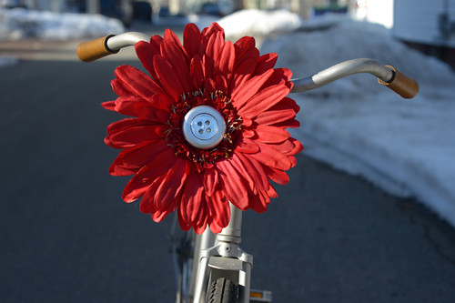
Pedal-Brite Flower Headlight
I received this awesomely whimsical headlight from a reader who has recently gone into business making them. Unable to find a bike light to match her cruiser, she made her own. The idea is to combine a headlight with the practice of attaching flowers to your bike. Handmade using jumbo silk daisies, the Pedal-Brite is reminiscent of the daisies adorning vintage plastic bike baskets. Battery-operated LED touch lights turns the giant flowers into functional, bright headlights. Pedal-Brites can be attached to a basket or handlebars, and everything you need for that is included. These flowers are quite large (12" in diameter) and are best suited for cruiser-type bikes. In addition to the red flower pictured, they are also available in white, yellow, orange, purple, turquoise and pink for a price of $30 on the Pedal-Brite website.
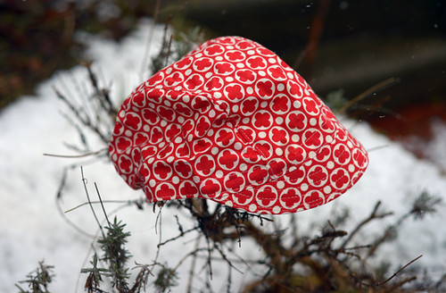
Little Package Lightweight Cycling Cap
Handmade items can be more accessible than you think. Did you know there is a woman in Oregon sewing cycling caps for as little as $15?In addition to selling ready to wear hats, Caroline also takes custom orders, and can use either her own or customer-supplied fabrics.This lightweight 3-panel cotton cap features a red and white pattern that is no longer available, but the fit and construction are similar to this model(and othersin her Etsy shop). Featuring a soft bill, this is a summer weight cap, for warmer days of which for now we can only daydream here on the East Coast, given the latest "weather event." I would say this cap runs small-ish, or at least looks best on women with small to average sized heads.
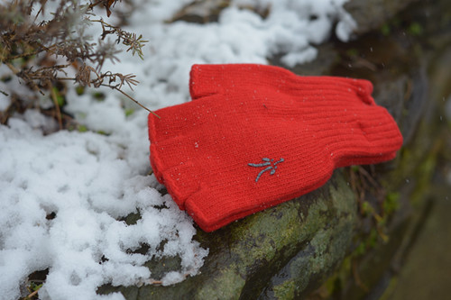
Ibex Knitty-Gritty Fingerless Gloves
Perfect for transitional weather, these wool fingerless gloves from Ibex are bright red with silver logos (also available in black on the Ibex websitefor $20). The gloves are made of lambswool with a touch of nylon for stretch.The underside features rubber grippers like so, excellentfor gripping bicycle handlebars or holding a camera.This pair is size S/M unisex - which is more like aMedium/Large when translated to women's sizing.
If you would like to enter, here are the eligibility criteria:
1. Women only, in the continental USA please
2. Provide a functional email address
3. Be sure to list which item you are interested in (see below)
And here is what to do:
Post a comment telling us what you and your bike are up to today. Anything Woman's-Dayish? I am always curious whether anyone in the US celebrates this holiday, and how. If you're doing nothing, that's fine too, this plays no role in selecting recipients. Somewhere in the comment, let me know which item(s) you are interested in (flower, cap, or gloves). It can be just one, or all three; I simply need to know which draw to include you in. Recipients will be chosen at random from eligible entries. Don't forget to include your email!
Deadline:
Saturday, March 9th, 11:55pm
Thank you for reading, Happy Women's Day, and enjoy your weekend!
Tuesday, May 10, 2011
Bald Eagle on the bay
Just a quick post today to share a few images of the Bald Eagle that was perched across the road from my driveway. It was kind of a rainy day, and this eagle sat out there for about an hour.
Sunday, May 8, 2011
Hot Chickens
When chickens are hot, they breathe through their mouths.
I started playing with the effects on the photo program.
Hot waxed chicken.
Solarized hot wax chicken.
Friday, May 6, 2011
Tombstone Tuesday :: Elsie Shuder and Charles Wiseman
North Webster Cemetery, North Webster (Kosciusko County), Indiana
Elsie Shuder was the daughter of Isaac and Nancy Jane (Lavering) Shuder. She was born on August 18, 1885 in Tippecanoe Township, Kosciusko County, Indiana. The inscription shows her year of birth as 1886 but her marriage application and death record both show that she was born in 1885. Elsie perished in a house fire on February 3, 1926 leaving eight children between the ages of 2 and 16. She was 40 years old. My father was the youngest of the children.
Charles Wilson Wiseman was born on September 20, 1885 also in Tippecanoe Township. The inscription shows his year of birth as 1886 but his marriage application, WWI Draft Registration Card, and Certificate of Death all give his year of birth as 1885. He was the son of Samuel Bray and Amanda Minerva (Alexander) Wiseman. It was said that Charlie made the best moonshine and was the best one-armed card shark in the county. (In 1908, his right arm had been amputated below the elbow after an accident with a cement mixer.) Charlie passed away on January 28, 1943 at McDonald Hospital in Warsaw, Indiana.
Wednesday, May 4, 2011
Shops
Many of the shops in Old Town were first residents, some over 200 years old. There are still people that live over their shops or behind them.
Subscribe to:
Posts (Atom)